TRMM
Tropical Rainfall Measuring Mission
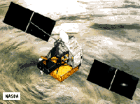 TRMM is an international mission dedicated to measuring tropical and subtropical rainfall, one of the most important and least-known parameters affecting the global climate system. The latent heat released by this rainfall plays a major role in the global atmospheric circulation and the energy budget. TRMM will provide long-term data sets of rainfall and energy budget measurements which will be used to better understand global climate changes and their mechanisms. The
large spatial and temporal variations in tropical rain make it particularly difficult to measure from the Earth's surface, and TRMM will provide measurement accuracies possible only from an orbiting platform. The spacecraft and four instruments will be provided by the
US, while Japan will provide one instrument and launch services.
TRMM is an international mission dedicated to measuring tropical and subtropical rainfall, one of the most important and least-known parameters affecting the global climate system. The latent heat released by this rainfall plays a major role in the global atmospheric circulation and the energy budget. TRMM will provide long-term data sets of rainfall and energy budget measurements which will be used to better understand global climate changes and their mechanisms. The
large spatial and temporal variations in tropical rain make it particularly difficult to measure from the Earth's surface, and TRMM will provide measurement accuracies possible only from an orbiting platform. The spacecraft and four instruments will be provided by the
US, while Japan will provide one instrument and launch services.
Spacecraft
3-axis stabilized, zero momentum bias. Two solar panels provide 1100 W. Downlink via TDRSS.
Payload
Clouds and the Earths Radiant Energy System (CERES) - a passive broadband scanning radiometer with 3 spectral bands (visible through IR) that will measure the Earth's radiation budget and atmospheric radiation from the top of the atmosphere to the surface of the Earth. Lightning Imaging Sensor (LIS) - an optical telescope and filter imaging system which will investigate the distribution and variability of both intracloud
and cloud-to-ground lightning over the earth. Data from this experiment will allow for the derivation of a lightning climatology over the tropics and relate the lightning observations to the rainfall distribution in tropical systems. Precipitation Radar (PR) - the first
spaceborne rain radar in the world, PR's major obectives are to (1) provide 3-dimensional rainfall structure data, (2) provide quantitative rainfall measurements, and (3) improve the
accuracy of TRMM Microwave Imager (TMI) measurement by providing rain structure information. This phased array radar operates at 13.8 Ghz with a swath width of 215 km. TRMM Microwave Imager (TMI) - a multi-channel/dual-polarized microwave radiometer that will provide data related to rainfall rates over the oceans. TMI data, together with PR data, form the primary data set of precipitation measurement. The imager
operates at 10.7, 19.4, 21.3, 37 and 85.5 Ghz, has a swath width of 760 km and provides 6-50 km horizontal resolution. Visible Infrared Scanner (VIRS) - a passive cross-track scanning radiometer which measures scene radiance in five spectral bands
(visible through infrared). VIRS has a 720 km swath width and provides 2 km horizontal resolution.
| Country of Origin | United States and Japan |
| Customer/User | NASA, NASDA |
| Launch | Planned for Summer of 1997 on H-2 |
| Orbit | 350 km circular, 35 deg inclination |
| Design Life | 3 years |
| Related Sites | NASDA TRMM Page |
Information in The Mission and Spacecraft Library is provided without warranty or guarantee. USE AT YOUR OWN RISK.