Radarsat
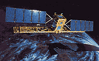 Canada's Radarsat is a radar satellite featuring variable resolution, and different view angles at a number of preset positions. This sophisticated remote sensing satellite is a Canadian-led project involving the United States. It will carry a Synthetic Aperture Radar (SAR), a powerful microwave instrument that can transmit and receive signals to "see" through clouds and darkness, obtaining detailed images of the Earth. This will provide significant advantages in viewing under conditions that preclude observation by aircraft or optical satellites. RADARSAT collects data on resource management, ice, ocean and environmental monitoring and Arctic and off-shore surveillance. RADARSAT will also support fishing, shipping, oil exploration, offshore drilling and ocean research. The RADARSAT will provide complete global coverage with the flexibility to support specific requirements.
Spacecraft
The spacecraft solar array provides 2.1 kW of power. The three NiCd batteries are rated at 48 Ah. Cube shaped bus, with an earth facing SAR antenna measuring 15 meters across.
Payload
Using a single 5.3 GHz C-Band SAR with a wavelength of 5.6 cm, Radarsat will have the unique ability to shape and steer its beam over a 500 kilometer range. Beam selections can image swaths from 35 kilometers to 500 kilometers with resolutions from 10 meters to 100 meters respectively. Incidence angles will range from less than 20 degrees to 60 degrees via a steerable antenna. The RF bandwidth of the system varies between 1.6, 17.3 or 30.0 Mhz, with a peak transmitter peak of 5kW. The maximum data rate is 85 Mb/s (recorded) or 105 Mb/s (in real time).
| Country of Origin | Canada |
| Customer/User | Canadian Space Agency (CSA) |
| Manufacturer(s) | SPAR Aerospace, Ball Space Systems |
| Size | 1.2 meter cube, antenna 1.5 x 15 meters |
| Orbit | Sun-synchronous 793x821 km; incl.= 98.6 degrees; period=101 min. |
| Design Life | 5 years |
| Related Sites | Radarsat |
Launch Facts
| Name | Int'l Desig. | Date | Site | Vehicle | Orbit | Mass(kg) |
| Notes | ||||||
| Radarsat 1 | 1995-059A | 11/4/95 | WSMC | Delta 7920 | LEO | 2713 |
| Earth imaging with synthetic aperture radar | ||||||
Information in The Mission and Spacecraft Library is provided without warranty or guarantee. USE AT YOUR OWN RISK.