Priroda
Part of the Mir Space Station program
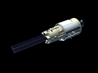 Priroda ("Nature") is the last of the Mir modules, and completed Mir's orbital construction efforts started ten years prior to its launch. The module's primary purpose is Earth remote sensing. The mission's internationally provided experiments will support a six-point research program for (1) determination of the atmosphere-ocean system characteristics, (2) measurements of the land local characteristics, (3) measurements of optical characteristics of the atmosphere, (4) investigation of the sea surface roughness state, (5) comparison of radiation and reflection characteristics of the sea surface in the microwave range, and (6) measurements of the concentrations of trace gases in the atmosphere.
Specific remote sensing objectives include measurements of ocean surface temperatures to within 0.5 deg K, measurements of surface wind velocities to within 1 m/s and +/-20 deg., atmospheric temperature profile to within 3K, sea wave height measurements to within 20 cm, and cloud temperature measurements to within 1K.
The vehicle also supports materials science, space technology, biotechnology and life sciences studies.
The module has a total pressurized volume of 66 cubic meters.
The module originally docked with the station on April 26, 1996. It was transferred to its final location at the Mir core module's port radial docking port on April 27, 1996.
Spacecraft
The module does not carry any solar arrays and must rely on its internal battery system when not attached to the station. 2 3.9 kN main engines and 400N attitude control thrusters were used during the initial docking process.
Payload
Ainur electrophoresis unit
Korund 1MP semiconductor unit
Ikar N nadir microwave radiometers - 0.3, 0.8, 1.35, 2.25 6.0 micrometer wavelengths, resolution up to 60km and 0.15 deg. K
Ikar D scanning mirowave radiometer system - scans 40 deg off track with a 400 km swath. 4.0, 0.3, 0.8, 1.35 micrometer wavelengths, resolution up to 5 km and 0.15 deg. K
Ikar P panoramic microwave radiometers - 2.25, 6.0 micrometer wavelengths, 750 km swath, resolution up to 75 km and 0.15 deg. K
Istok 1 IR spectroradiometer - wavelengths between 4.0-16.0 micrometer, 7 km swath, 0.7x2.8 km resolution
Ozon M spectrometer - used for ozone/aerosol profiles. 160 channels between 0.257-1.155 micrometer, 1 km altitude resolution
Travers Synthetic Aperture Radar - 1.28/3.28 GHz, 50 km swath, 38 deg. look angle, 50 m resolution
Alissa lidar - measures cloud height, structure, optical properties. 150 m vertical resolution, 1 km horizontal resolution
MOS-Obzor spectrometer - measures aerosol profile and ocean reflectance. 17 channels between 0.750-1.01 micrometer, 80km swath, 700 m resolution
MSU-E2 high resolution optical scanner - 10 m resolution, 3 channels between 0.5 and 0.9 micrometer, nadir viewing, 2 x 24.5 km swaths
DOPI interferometer - studies gases and aerosols. 2.4-20 micrometer
Greben ocean altimeter - 10 cm resolution, 13.76 GHz, 2.5 km swath, nadir viewing
Centaur 400 MHz receiver - used to gather ocean buoy data
MOMS 02P Earth imager - 4 channels between 0.440-0.810 micrometer. Multi spectral, stereo or high resolution data, 6 km resolution. Initially flown aboard Spacelab D2 on Shuttle. Added May 1996
| Country of Origin | USSR |
| Size | 13 m long x 4.35 m diameter |
Launch Facts
| Name | Int'l Desig. | Date | Site | Vehicle | Orbit | Mass(kg) |
| Notes | ||||||
| Priroda | 1996-023A | 4/23/96 | Tyuratam | SL-13 | LEO | 19000 |
| Remote sensing module for Mir space station | ||||||
Information in The Mission and Spacecraft Library is provided without warranty or guarantee. USE AT YOUR OWN RISK.