MOS 1A, 1B
Marine Observation Satellite
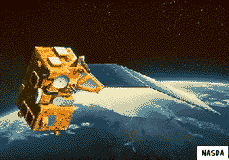 The MOS 1A and 1B satellites, also known as Momo 1A and 1B, were Japan's first Earth resources satellites. The satellites were designed to monitor ocean currents, sea surface temperature, atmospheric water vapor, ocean chlorophyll levels, precipitation, and land vegetation. They also acted as relays for data from remote surface sensor platforms. MOS 1B was upgraded for flight from the engineering model for MOS 1A.
Spacecraft
3-axis stabilized with momentum wheels, hydrazine thrusters. Nadir pointing. S-, X-band downlink, S-band uplink. Single solar panel with 1-axis articulation.
Payload
Multispectral Electronic Self-Scanning Radiometer (MESSR) - covers 4 bands between 0.51 and 1.1 micron, 50 m resolution, 200 km swath. Designed to observe ice distribution, land use, snowcover,
ocean chlorophyll. Visible and Thermal Infrared Radiometer (VTIR) - covers 6 bands between 0.5 and 12.5 microns, 0.9 - 2.7 km resolution, 1500 km swath. Designed to monitor snow, cloud, ice coverage, sea surface temperatures. Microwave Scanning Radiometer (MSR) - 2 frequency radiometer
(23.8, 31.4 GHz) with 23-32 km resolution, 317 km swath. Montiors atmospheric water vapor content, snowfall, and rainfall.
| Country of Origin | Japan |
| Customer/User | NASDA |
| Manufacturer(s) | NEC |
| Size | 1.3 x 2.4 x 1.5 m (bus), 5.3 x 2 m solar panel |
| Orbit | 909 km circular, sun-synchronous, 99 deg inclination, with 17 day repeat period and 10 am descending node |
| Design Life | 2 years |
| Related Sites | NASDA MOS Page |
Launch Facts
| Name | Int'l Desig. | Date | Site | Vehicle | Orbit | Mass(kg) |
| Notes | ||||||
| MOS 1A (MOMO 1) | 1987-018A | 2/18/87 | Tanegashima | N-2 | LEO | 745 |
| Ocean remote sensing | ||||||
| MOS 1B (MOMO 1B) | 1990-013A | 2/7/90 | Tanegashima | H-1 | LEO | 740 |
| Marine observation | ||||||
Information in The Mission and Spacecraft Library is provided without warranty or guarantee. USE AT YOUR OWN RISK.