Landsat 1, 2, 3
Part of the Landsat program
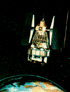 The first 3 Landsat missions were also known as the Earth Resources Technology Satellite (ERTS) series. Images from Landsat 1 demonstrated the usefulness of remote sensing data for land surveys, land management, water resource planning, agricultural forecasting, forest management, sea ice movement, and cartography. When Landsat 1 was finally removed from service in January 1978 due to tape recorder faults, it had returned over 300000 images. Landsat 2 was removed from service on 2/25/82, and Landsat 3 was removed from service on 3/31/83. Archived images from these missions are available through EOSAT.
Spacecraft
The spacecraft design had significant inheritance from the Nimbus program (also manufactured by General Electric). 3-axis stabilized using 4 momentum wheels to 0.7 deg accuracy. Twin solar paddles (single-axis articulation) provided 1000 W (BOL peak), 515 W (BOL ave). NiCd batteries. S-Band
and VHF communications with 1 W transponder. Hydrazine propulsion system with 3 thrusters. Data downlink rate of 15 Mbps.
Payload
Carried Return Beam Vidicon (RBV) and Multi-Spectral Scanner (MSS) imaging sensors. The MSS covers 0.5 to 12.6 µ m and provides 75 m resolution at best with a 185 km swath width. The RBV covers 0.5 to 0.75 µ m and provides 40 m resolution with a 185 km swath width. Payload mass was about 150 kg.
| Country of Origin | United States |
| Customer/User | NASA, GSFC |
| Manufacturer(s) | GE Astro Space |
| Size | 59 inch diam. bus, 119 inches tall, 13 ft solar array span |
| Orbit | Each nearly exactly 900 x 920 km, sun-synchronous (99 deg inclination) |
| Design Life | 1 year |
| Related Sites | EOSAT Home Page EOSAT Reference Page at Harvard NASA Landsat Page Jennifer Green's Landsat Page |
Launch Facts
| Name | Int'l Desig. | Date | Site | Vehicle | Orbit | Mass(kg) |
| Notes | ||||||
| Landsat 1 (ERTS 1) | 1972-058A | 7/23/72 | WSMC | Delta 900 | LEO | 816 |
| Earth Resources Technology Satellite | ||||||
| Landsat 2 (ERTS 2) | 1975-004A | 1/22/75 | WSMC | Delta 2910 | LEO | 953 |
| Landsat 3 (ERTS 3) | 1978-026A | 3/5/78 | WSMC | Delta 2910 | LEO | 960 |
Information in The Mission and Spacecraft Library is provided without warranty or guarantee. USE AT YOUR OWN RISK.