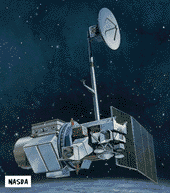
Landsat 4, 5
Part of the Landsat program
 The Landsat 4 and 5 spacecraft were placed into lower orbits than the previous Landsat spacecraft and carried improved instrument suites. Beginning in 1983, Landsat 4 began
experiencing numerous spacecraft malfunctions which limited spacecraft functionality. This prompted the early launch of Landsat 5 to guarantee continued coverage. Management of the spacecraft was
transferred from NASA to NOAA with Landsat 4.
Spacecraft
Structure of aluminum with graphite struts. Hydrazine propulsion system. Single solar array with 1-axis articulation produces 1430 W (BOL), Two NiCd batteries provide 100 AHr total. Retractable boom (4 m long) with 2 powered joints supports the articulated HGA which downlinks data via TDRSS. Communications system uses S, X, L, and Ku-Bands. 3-axis stabilized, zero momentum
with control to 0.01 deg using reaction wheels. Shortly after launch, Landsat 4 lost use of half its solar power. Landsat 5 lost two of its primary communications systems (X-Band downlink and a Ku-Band TDRSS transponder) and backup systems were activated.
Payload
Carried Multi-Spectral Scanner (MSS) and Thematic Mapper (TM) imaging sensors. TM provides 7 bands of coverage and the MSS has 4 bands. The MSS covers 0.5 to 12.6 µ m and provides 80 m resolution with a 185 km swath width. TM covers 0.45 to 12.5 µ m with resolution of 30 meters in the VIS/IR bands and 120 m in the thermal/IR bands.
| Country of Origin | United States |
| Customer/User | NASA, GSFC, NOAA, EOSAT |
| Manufacturer(s) | GE Astro Space, Fairchild |
| Size | 4.3 m high, 2.2 wide (with HGA and array deployed) |
| Orbit | 705 km circular, polar, sun-synchronous, repeating every 16 days (9:45 am crossing time) |
| Design Life | 5 years |
| Related Sites | EOSAT Home Page EOSAT Reference Page at Harvard NASA Landsat Page Jennifer Green's Landsat Page |
Launch Facts
| Name | Int'l Desig. | Date | Site | Vehicle | Orbit | Mass(kg) |
| Notes | ||||||
| Landsat 4 | 1982-072A | 7/16/82 | WSMC | Delta 3920 | LEO | 1942 |
| Landsat 5 | 1984-021A | 3/1/84 | WSMC | Delta 3920 | LEO | 1938 |
Information in The Mission and Spacecraft Library is provided without warranty or guarantee. USE AT YOUR OWN RISK.