LAGEOS 1, 2
LAser GEOdynamics Satellite
 The LAGEOS satellites are passive vehicles covered with retroreflectors designed to reflect laser beams transmitted from ground stations. By measuring the time between transmission of the beam and reception of the reflected signal from the satellite, stations can precisely measure the distance between themselves and the satellite. These distances can be used to calculate station positions to within 1-3 cm. Long term data sets can be used to monitor the motion of the Earth's tectonic plates, measure the Earth's gravitational field, measure the "wobble" in the Earth's axis of rotation, and better detemine the length of an Earth day. LAGEOS 1 was developed by NASA and was placed into a high inclination orbit to permit viewing by ground stations
located around the world. LAGEOS 2 was a joint program between NASA and the Italian space agency (ASI), which built the satellite using LAGEOS 1 drawings and specifications, handling fixtures, and other materials provided by NASA. LAGEOS 2's orbit was selected to provide more coverage of seismically active areas, such as the Mediterranean Basin and California, and may help scientists understand irregularities noted in the motion of LAGEOS 1. Ground tracking stations are located in many countries (including the US, Mexico, France, Germany, Poland, Australia, Egypt, China, Peru, Italy, and Japan) and data from these stations is available worldwide to investigators studying crustal dynamics. LAGEOS 1 also contains a message plaque addressed to human and other beings of the far distant future with maps of the Earth from 3 different eras - 268 million years in the past, present day, and 8 million years in the future (the satellite's estimated decay date).
The LAGEOS satellites are passive vehicles covered with retroreflectors designed to reflect laser beams transmitted from ground stations. By measuring the time between transmission of the beam and reception of the reflected signal from the satellite, stations can precisely measure the distance between themselves and the satellite. These distances can be used to calculate station positions to within 1-3 cm. Long term data sets can be used to monitor the motion of the Earth's tectonic plates, measure the Earth's gravitational field, measure the "wobble" in the Earth's axis of rotation, and better detemine the length of an Earth day. LAGEOS 1 was developed by NASA and was placed into a high inclination orbit to permit viewing by ground stations
located around the world. LAGEOS 2 was a joint program between NASA and the Italian space agency (ASI), which built the satellite using LAGEOS 1 drawings and specifications, handling fixtures, and other materials provided by NASA. LAGEOS 2's orbit was selected to provide more coverage of seismically active areas, such as the Mediterranean Basin and California, and may help scientists understand irregularities noted in the motion of LAGEOS 1. Ground tracking stations are located in many countries (including the US, Mexico, France, Germany, Poland, Australia, Egypt, China, Peru, Italy, and Japan) and data from these stations is available worldwide to investigators studying crustal dynamics. LAGEOS 1 also contains a message plaque addressed to human and other beings of the far distant future with maps of the Earth from 3 different eras - 268 million years in the past, present day, and 8 million years in the future (the satellite's estimated decay date).
Spacecraft
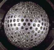
Both satellites are spherical bodies with an aluminum shell wrapped around a brass core. The design was a comprimise between numerous factors includings the need to be as heavy as possible to minimize the effects of non-gravitational forces vs. being light enough to be placed in a high orbit and the need to accommodate as many retroreflectors as possible vs. the need to minimize surface area to minimize the effects of solar pressure. The materials were chosen to reduce the effects of the Earth's magnetic field on the satellite's orbit. 426 cube-corner retroreflectors are imbedded in the satellites'
surface. 422 of these are made of fused silica glass while the other 4 are made of germanium. The vehicles have no onboard sensors or electronics, and are not attitude controlled.
Payload
Science is performed by reflecting laser light from the vehicle's 426 retroreflectors.
| Country of Origin | 1: USA / 2: Italy |
| Customer/User | NASA, Agenzia Spaziale Italiana (ASI) |
| Manufacturer(s) | NASA Goddard Space Flight Center, Bendix Aerospace Systems, Aeritalia |
| Size | 0.6 m dia. sphere |
| Orbit | 1: 5858 x 5958 km, incl. = 109.8 deg. / 2: 5616 x 5950 km, incl. = 52.6 deg. |
| Design Life | 50 years |
| Related Sites | Jennifer Green's LAGEOS Page |
Launch Facts
| Name | Int'l Desig. | Date | Site | Vehicle | Orbit | Mass(kg) |
| Notes | ||||||
| Lageos 1 | 1976-039A | 5/4/76 | WSMC | Delta 2913 | MEO | 411 |
| Lageos 2 | 1992-070B | 10/22/92 | ESMC | STS 52 | MEO | 400 |
| 60 cm diameter sphere with laser reflectors; deployed from STS-52 10/23/92 | ||||||
Information in The Mission and Spacecraft Library is provided without warranty or guarantee. USE AT YOUR OWN RISK.