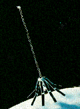
Geosat
Geodetic Satellite
 Geosat was a US Navy satellite designed to measure sea surface heights to within 5 cm. After a one-and-a-half year long classified mission for the Navy, Geosat's scientific Exact Repeat Mission (ERM) began on November 8, 1986. When the ERM ended in January 1990 (due to failures of both on-board tape recorders), more than three years of precise altimeter data were available to the scientific community.
Spacecraft
Gravity gradient stabilized. Two tape recorders.
Payload
Radar altimeter to measure sea surface height.
| Country of Origin | United States |
| Customer/User | US Navy |
| Manufacturer(s) | JHU/APL |
| Orbit | 760 x 817 km, incl. = 108.05 deg, 17 day exact repeating orbit |
| Design Life | 3 years |
| Related Sites | Geosat Follow On page |
Launch Facts
| Name | Int'l Desig. | Date | Site | Vehicle | Orbit | Mass(kg) |
| Notes | ||||||
| Geosat | 1985-021A | 3/13/85 | ESMC | Atlas E | LEO | 635 |
| Ocean sea height mapping | ||||||
Information in The Mission and Spacecraft Library is provided without warranty or guarantee. USE AT YOUR OWN RISK.