ERS 1,2
European Remote Sensing Satellite
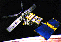 The primary mission of ERS-1 and -2 is to perform remote sensing of the Earth's oceans, ice caps, and coastal regions. The satellites will provide systematic, repetitive global measurements of wind speed and direction, wave height, surface temperatures, surface altitude, cloud cover, and atmospheric water vapor levels. Data from ERS-1 will be shared with NASA under a reciprocal agreement for Seasat and Nimbus 7 data. Some land imaging will be performed with the satellites' SAR experiment. The satellites will be controlled from ESA's Darmstadt control center, with a large number of other stations providing additional tracking coverage.
Spacecraft
3-Axis stabilized, zero momentum bias with control to 0.11 deg (pitch/roll) and 0.21 deg (yaw). Single solar panel is 11.7 m x 2.4 m and supports peak payload power of 2600 W. Battery storage capacity is 2650 WHr. SAR antenna is 10 m x 1 m. S-Band communications with 2 kbps uplink. High-rate X-Band downlink provides 105 Mbps and 15 Mbps. On-board recorders store 6.5 Gbits.
Payload
ERS-1 Payload: AMI (Active Microwave Instrument) - includes a SAR (Synthetic Aperture Radar), Wave Scatterometer, and Wind Scatterometer; Radar Altimeter (RA); Scanning Radiometer and Sounder (ASTR-M); Laser Reflector (LRR) - used for precise orbit determination and RA calibration; Precision Ranging Equipment
(PRARE) - used for orbit determination.
ERS-2 Payload: ERS-2 carries the same suite of instruments as ERS-1 with the addition of the Global Ozone Measuring Equipment (GOME) which measures ozone distribution in the outer atmosphere.
AMI SAR
| Country of Origin | Europe |
| Customer/User | ESA |
| Manufacturer(s) | Matra Marconi, Dornier Systems |
| Size | 11 m long |
| Orbit | ERS-1: 777 km circular, sun synchronous, 98.5 deg inclination, with a repeat periods of 3 days, 35 days or 176 days ERS-2 orbit will be similar |
| Design Life | 3 years |
| Related Sites | NASDA ERS Page |
Launch Facts
| Name | Int'l Desig. | Date | Site | Vehicle | Orbit | Mass(kg) |
| Notes | ||||||
| ERS 1 | 1991-050A | 7/17/91 | Kourou | Ariane 4 | LEO | 2384 |
| Microwave, IR imaging of oceans, ice and land; SAR | ||||||
| ERS 2 | 1995-021A | 4/21/95 | Kourou | Ariane 40 | LEO | 2516 |
| European Remote Sensing; carried SAR; ocean, land, ice, and atmospheric observations | ||||||
Information in The Mission and Spacecraft Library is provided without warranty or guarantee. USE AT YOUR OWN RISK.